Did you know that many of the most significant waterbodies in the northeast are located in Ulster County? The westernmost portion of the County is often referred to as the "birthplace of American fly-fishing" because of the pristine headwaters of the Neversink, Beaverkill, Rondout, and Esopus Creeks. Two major reservoirs (the Ashokan and Rondout) provide the City of New York with 45 % of its unfiltered drinking water every day. The famous Hudson River, forming the eastern boundary of Ulster County, provides not only ample recreational opportunities, is a huge driver behind the County's $500M annual tourism industry, but also continues to serve as an important route for commerce.
The Hudson River and its Watershed
The eastern boundary (38 miles long) of Ulster County is formed by the Hudson River. The Hudson River in Ulster County is more than a river. It is a tidal estuary, meaning that it is like an arm of the ocean where salty sea water meets fresh water running off the land. It is often thought of as a "river that flows two ways". For more information on the river and its estuary, visit the NYSDEC's Hudson River Estuary Program webpage. There are numerous organizatons that work to protect and improve the Hudson River and its communities. Several of these entities, and many of the USGS stream gaging station locations (link to real-time and historical data) are listed below.
The Wallkill River Watershed
Wallkill River Watershed Alliance
USGS Stream Gages:
The Rondout Creek Watershed
Rondout Creek Watershed Council
Rondout-Neversink Stream Program (upper Rondout)
USGS Stream Gages:
Rondout Creek near Lowes Corners
The Esopus Creek Watershed
The Lower Esopus Creek |
|
|
ISSUE BRIEF from Ulster County Executive Hein on NYC DEP Pollution of the Lower Esopus Creek (01/18/11) Lower Esopus Creek Order on Consent - NYSDEC (October 2013) Lower Esopus Creek Consent Order FAQ
Ashokan Release Working Group (ARWG) and Spill Release Data USGS Stream Gages: USGS Stream Gage at Lamontville
|
Lower Esopus Creek Watershed Recreational Access Map 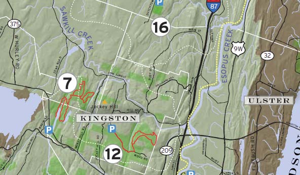 Click on map to view full-zize map |
The Upper Esopus Creek
Ashokan Watershed Stream Management Program
USGS Stream Gages:
Diversion to Esopus from Schoharie Reservoir (the "Portal")
Little Beaverskill at Beechford
The Delaware River Watershed
The Delaware River rises in two main branches that descend from the western flank of the Catskill Mountains, including the Ulster County townships of Denning and Hardenburgh. These two branches flow west and merge near Hancock in Delaware County and the combined waters flow as the Delaware River south. Through its course, the Delaware River forms the boundaries between Pennsylvania and New York, the entire boundary between New Jersey and Pennsylvania, and most of the boundary between Delaware and New Jersey.
The Neversink River
Rondout-Neversink Stream Program (East and West Branches Neversink River)
USGS Stream Gages:
East Branch Neversink near Claryville
West Branch Neversink near Claryville